
| Project Home | About the Scans | Browse Gallery | Image Map | Support Data | Resources | Ephemeris |
Featured Image - 07/01/2008
Imbrium Islands in a Lava Sea
Apollo metric image AS15-M-2076 contains lunar massifs, sinuous rilles, mare lava flows, impact craters, and ejecta blankets. The wide variety of different lunar features of varying ages in this area provide an exciting opportunity to study the geology and stratigraphy of this region. Stratigraphy is the study of rock and soil layers and the order in which they formed. Younger materials usually overlie older materials. Using stratigraphy, we can determine the relative ages of each of the geologic features in this image and uncover the series of geologic events that ultimately led to the current scene. Stratigraphy can also help lunar mappers create geologic maps -- see the April 1, 2008 Apollo Featured Image for more information about how geologic maps of this region were created. This week we will discuss the geology of this area.
Figure 1 below (AS15-M-2076) is an annotated image of the region around Delisle and Diophantus craters. This region lies on the southwestern edge of the Imbrium basin and on the northeastern edge of the Aristarchus plateau. The Imbrium basin is believed to have formed about 3.8 billion years ago. The Aristarchus plateau is an elevated region of more recent volcanic activity. The oldest materials in this image are the mountainous features (1) called lunar massifs which are thought to be pieces of the underlying Imbrium basin. The massifs are remnants of an older fractured and faulted lunar crust and here remain as islands surrounded by younger mare units in the Imbrium basin.
Next, mare lavas (2) filled this region and surrounded the Imbrium massifs. Mare unit 2 is overlain by ejecta from Delisle crater at (3), illustrating that the mare surface is older than Delisle and the ejecta thrown out during that impact. Mare unit (4) contains sinuous rilles and may be younger than Delisle crater because it appears to embay the ejecta from Deslile. During embayment, mare lavas surround topographic highs and fill in topographic lows as they flow across the lunar surface, thereby partially covering low-lying older ejecta materials. Secondary craters (5) -- numerous small bowl-shaped craters formed when large blocks of debris were thrown outward during the impact that formed Diophantus -- observed on both Delisle crater and on mare unit (4) imply that this crater is the youngest of the large geologic features in the scene.
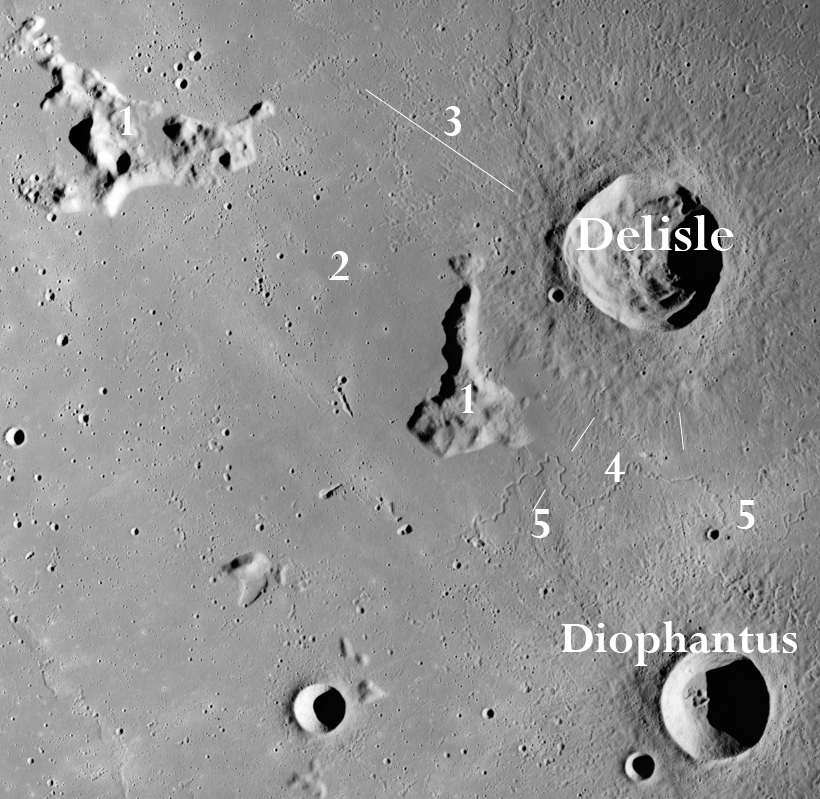
Figure 1: Stratigraphy and geology of the Delisle/Diophantus Region. (1) Imbrium massifs, (2) mare unit, (3) Delisle ejecta, (4) mare unit with sinuous rilles, (5) secondary craters from Diophantus. White lines trace impact ejecta from Delisle crater; ejecta covers mare unit 2 and is embayed by mare unit 4.
(Apollo Image AS15-M-2076 [NASA/JSC/Arizona State University])
References:
Wilhelms, Don E. (1987) The Geologic History of the Moon, U.S. Geological Survey Professional Paper 1348, p.18.


|
|
Space Exploration Resources |
|
|