| Project Home | About the Scans | Browse Gallery | Image Map | Support Data | Resources | Ephemeris |
Featured Image - 04/01/2008
Pre-Apollo Geologic Mapping
As the space race began, with the United States and the Soviet Union locked in an epic struggle to become the first nation to send human explorers to the Moon, we knew very little about the geologic nature of the Moon. One of the early efforts of geologic mapping of the near-side of the Moon was performed by the U.S. Geological Survey.
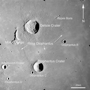
The image in Figure 1 was acquired by the Metric Camera on board the Apollo 15 command module Endeavour on August 8, 1971, during its 60th lunar orbit. The large prominent crater toward the north is Delisle Crater, with Diophantus Crater to the south. Between the two craters is a long (~150km) long rille named Rima Diaphontus.
Figure 1: Apollo Metric frame centered at latitude 28.9° N and longitude 326.2° E, with craters Delisle and Diophantus in view. (Apollo Image AS15-M-2074 [NASA/JSC/Arizona State University])
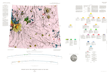
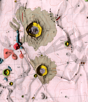
H.J. Moore created the geologic map of the Aristarchus Region shown in Figure 2 using telescopic observations (including visual observations using a 30 inch reflecting telescope and photographc plates produced by other contemporary lunar observation programs). The telescope observations provided a resolution of approximately 1.8 kilometers per pixel. In the close-up section of the map (Figure 3), you can see that the large craters and their ejecta blankets are mapped accurately. One notable feature that is missing from Moore's map is Rima Diophantus, though Moore did denote Rima Delisle to the north. This omission may have been in part due to the subdued nature of the Rima in the portion between Delisle and Diophantus craters. Other inconsistencies are also evident, based on the detail in the AS15-M-2074 Metric frame. However, in general, the dedicated individuals who performed the pre-Apollo geologic mapping did an excellent job mapping the distribution of geologic units on the lunar surface. As good as this mapping was, however, it took the direct explorations of the highly-trained Apollo astronauts to test the interpretations provided by these maps of the Apollo landing sites. Perhaps the most famous example occurred on the Apollo 16 mission, where the geologic unit boundaries at the Apollo 16 Descartes site were very well-mapped but he geologic interpretation was wrong. This was only corrected after astronauts John Young and Charlie Duke explored the Descartes highland region. Our current understanding of the Moon will undoubtedly be changed by both the scientific results of the current generation of lunar precursor spacecraft (including the U. S. Lunar Reconnaissance Orbiter, the Indian Chandrayaan-1, and Japan's Kaguya mission) and the next generation of human lunar landings.
Other maps in the U.S.G.S. series were created using both telescopic observations and results from the Lunar Orbiter spacecraft (which began operations in 1966). When Moore's geologic map was published in 1965, only 6 successful robotic lunar missions had been completed by the US and Russian space agencies.
 |
 |
| Figure 2: U.S. Geological Survey 1:1,000,000 scale geologic map of the Aristarchus Region, Near-Side of the Moon. | Figure 3: Close-up view of map showing same region as AS15-M-2074. |
References
Moore, H.J., 1965, Geological map of the Aristarchus region of the Moon: U.S.Gol. Survey Misc. Inv. Map I-465
Schaber, Gerald G., 2005, The U.S. Geological Survey, Branch of Astrogeoloy - A Chronology of Activities from Conception through the End of Project Apollo (1960 - 1973), Open-File Report 2005-1190

|
|
Space Exploration Resources |
|
 LPI LPI
|
