| Project Home | About the Scans | Browse Gallery | Image Map | Support Data | Resources | Ephemeris |
Featured Image - 03/04/2008
Lunar Scarps: Exploring the cliffs of the Moon
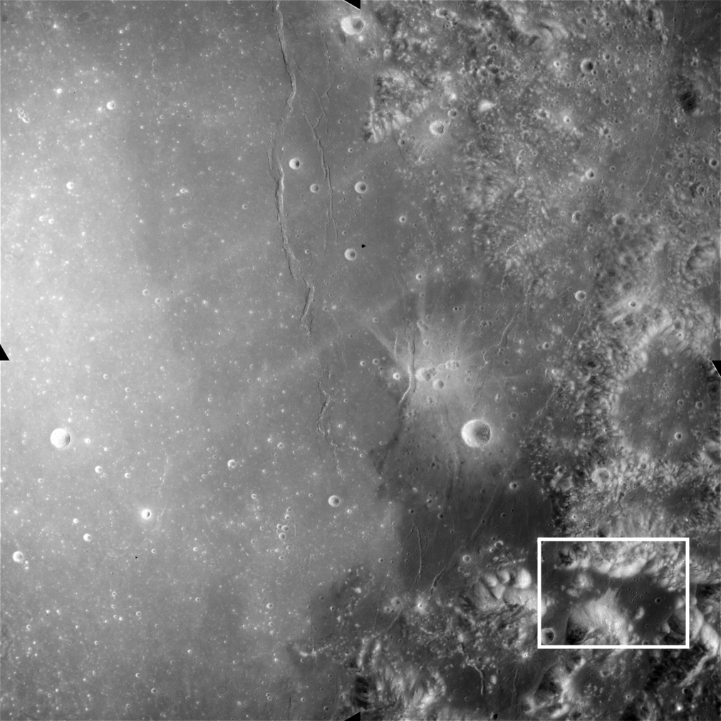
The landscape of the Apollo 17 landing site can only be described as dramatic. It is located in the Taurus-Littrow Valley on the southeastern rim of the Serenitatis basin, near Mare Serenitatis (Figure 1).

Figure 1. Apollo 15 metric frame AS15-M-0566, showing the Taurus-Littrow valley. The area shown in Figure 2 has been highlighted (Apollo Image AS15-M-0566 [NASA/JSC/Arizona State University])
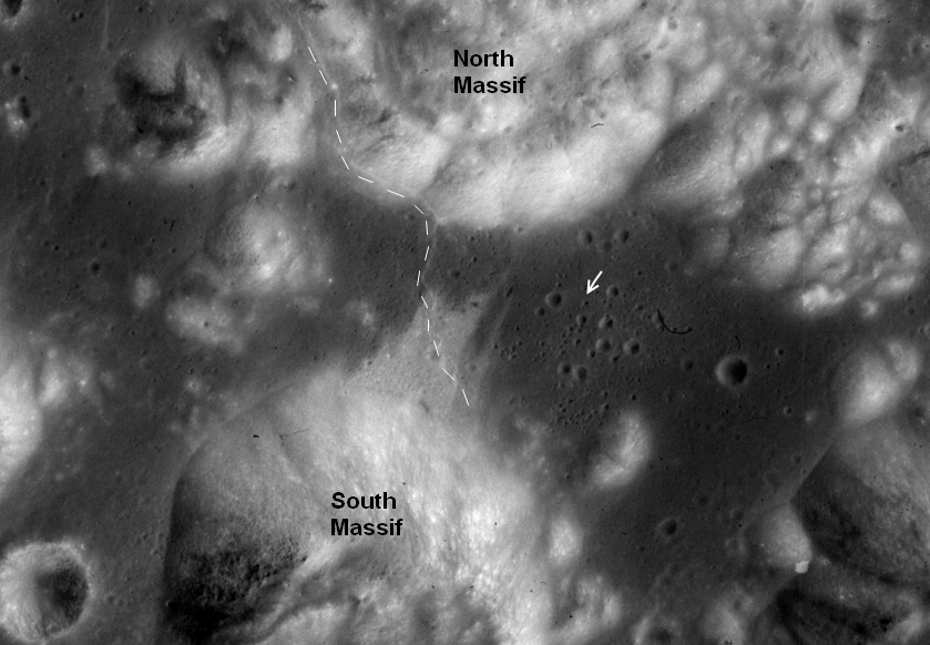
The Taurus-Littrow Valley lies between two hills called the South Massif and the North Massif (Figure 2). The floor of the valley is where United States Astronauts Eugene A. Cernan and Harrison H. Schmitt spent three days exploring in 1972, the last time to date that humans have directly explored another world. The floor of the valley is made up of mare basalts -- the same lavas that flooded Mare Serenitatis to the west. The relatively flat valley floor is interrupted by a scarp, called the Lee-Lincoln scarp, that trends roughly north-south between the South Massif and the North Massif.

Figure 2. Close-up view of the area highlighted in Figure 1, showing the Apollo 17 landing site (arrow). Some of the major geographic features of the Taurus-Littrow valley have been labeled. The location of the Lee-Lincoln scarp has been highlighted with a dotted line that is slightly to the left of the scarp's actual position. Close-up of Apollo 15 metric frame AS15-M-0566 (Apollo Image AS15-M-0566 [NASA/JSC/Arizona State University])
What is the origin of the scarp that offsets the floor of the Taurus-Littrow Valley?
The Lee-Lincoln scarp is an example of an important class of lunar tectonic features called lobate scarps. Lobate scarps are the visible part of a deep fault that cuts the lunar curst. Here, the crust was under compression form east-to-west (that is, squeezed from left to right) and something had to give. The ground on the left buckled and rode up over the ground on the right, creating the bulge you can clearly see here. The Lee-Lincoln scarp not only offsets the floor of the Taurus-Littrow Valley, it extends into the highlands of the North Massif up the side of the hill. Topographic maps of the Taurus-Littrow Valley made using the Apollo metric and panaoramic camera images show that the scarp reaches a height of about 80 m above the valley floor. The Apollo 17 astronauts actually drove across the southern section of the Lee-Lincoln scarp in the Lunar Roving Vehicle on their way to South Massif!
Lee-Lincoln scarp and other similar lunar scarps appear to be relatively young, because very few impact craters can be found on them. What is not understood is the source of contraction that formed these young thrust faults. The contraction and shortening may be related to heat loss from the Moon's interior, because as the Moon cooled down over time it shrank, but we don't know this for sure. That's one of the first things that the next explorers to visit the Moon will try to figure out! Future studies of lunar scarps using data obtained from the Lunar Reconnaissance Orbiter and future human exploration missions will help to unravel the root cause of these features and will shed light on the Moon's thermal history and, ultimately, its origin.
Tweet
|
|
Space Exploration Resources |
|
 LPI LPI
|