| Project Home | About the Scans | Browse Gallery | Image Map | Support Data | Resources | Ephemeris |
Welcome to the Apollo Digital Image Archive and the Featured Image!
Over the coming weeks and months, we will be using this space to highlight some spectacular products from a joint project between Johnson Space Center and Arizona State University to digitally preserve photographs acquired during the Apollo missions to the Moon. The NASA Apollo missions (1968-1972) that carried United States Astronauts to the lunar surface carried cameras to photograph the Moon both from orbit and on the lunar surface. These images are important records of our shared heritage in space and are of immense historical and scientific importance.
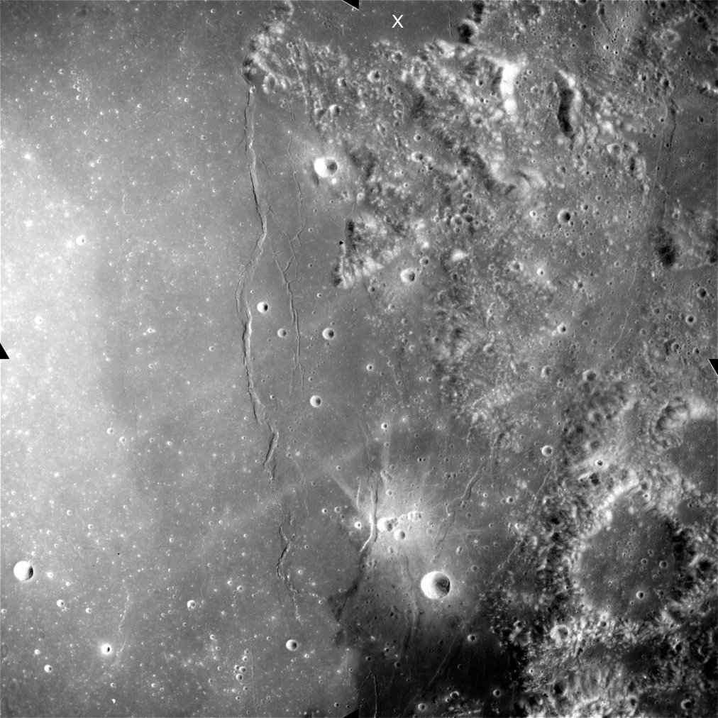
The Apollo Digital Image Archive is a sophisticated, interactive web-based interface designed to facilitate the use of these images for educational and scientific uses. Eventually, all of the metric, panoramic, and Hasselblad images will be made available, but this initial data release is comprised of metric mapping frames from the Apollo 15 mission (like Figure 1, below). Now that the Apollo Digital Image Archive site is live, we'd like to start by taking this opportunity to introduce the Apollo Lunar Mapping Camera system (Figure 2) to a new generation of users.
|
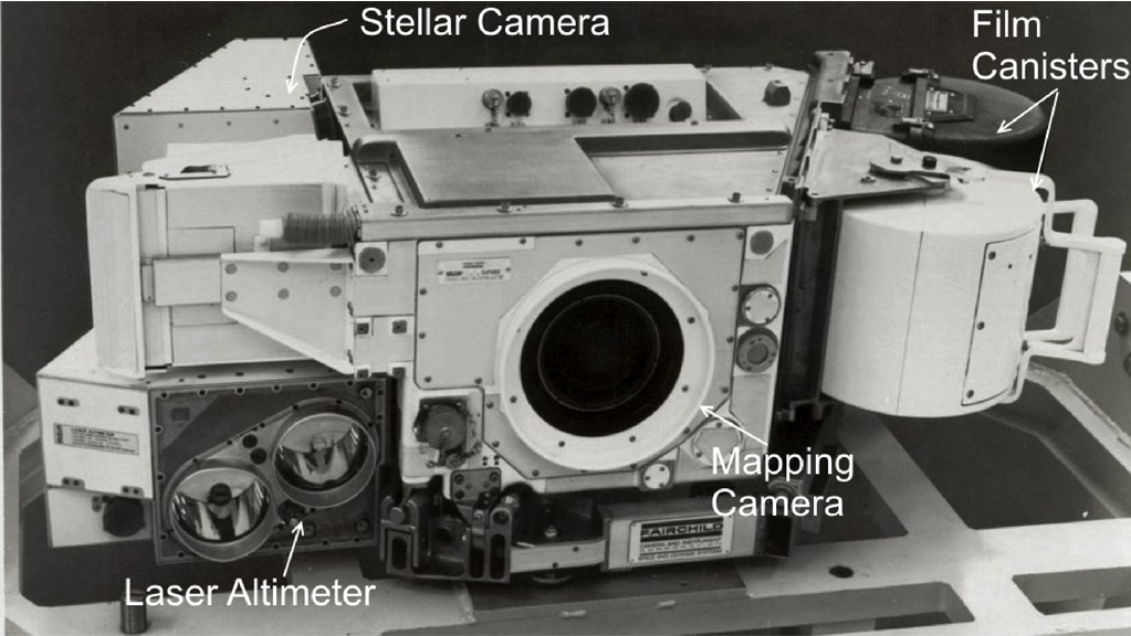 Figure 2. An Apollo Lunar Mapping Camera system prior to installation in the Scientific Instrumentation Module (SIM). It consists of a laser altimeter to record the altitude of the spacecraft above the lunar surface, a photogrammetric mapping camera to image the lunar surface, and the stellar camera to image the off-axis starfield in order to record the spacecraft's spatial orientation (NASA/Fairchild).
 |
The Apollo Lunar Mapping Cameras: Charting a New Frontier
The Apollo spacecraft system consisted of two major components: the lunar module (LM) and the Command/Service Module (CSM). The LM was designed to land two astronauts and their equipment on the surface of the Moon, while one astronaut remained aboard the CSM in lunar orbit to both monitor the situation at the landing site and perform scientific investigations in lunar orbit. Thanks to the foresight of the contractors and managers of Project Apollo, the original design specification of the Apollo spacecraft included an unused, vacant area in the Service Module part of the Apollo CSM that was reserved for new instrumentation designed to meet the mission goals of later Apollo missions.
Following the Apollo 13 mission, part of this vacant space in the Service Module was used to hold a third oxygen tank to mitigate another Apollo 13-style in-flight anomaly. After the successful completion of the Apollo 14 mission, the last Apollo missions were flown with significantly improved hardware that enabled longer and more ambitious missions to the Moon, and included improved spacesuits, a lunar rover, more consumables, and new instrumentation to investigate the Moon from orbit. This instrumentation was located in the remaining unused space in the vacant bay, an area called the Scientific Instrumentation Module (SIM) Bay.
The SIM Bay held an array of scientific instrumentation, including the
Apollo Lunar Mapping Camera system, which produced the metric mapping photographs currently available on the Apollo Digital Image Archive. The Apollo Lunar Mapping Camera only required a small part of the SIM bay (Figure 3); other
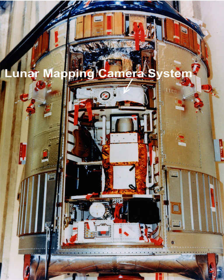 Figure 3. The Command/Service Module of Apollo 15 during pre-launch processing at the John F. Kennedy Space Center, Florida. The center of the image shows the open bay door where the Scientific Instrumentation Module (SIM) was installed and includes the Apollo Lunar Mapping Camera (NASA image S71-2250-X)
instruments that were carried in the SIM Bay on Apollos 15 and 16 included a panoramic camera, as well as X-ray, Alpha-particle, gamma-ray, and mass spectrometers to investigate the properties of the lunar surface.
Apollo 17 carried a slightly different set of instruments, including the mapping and panoramic camera systems, a radar system, an infrared scanning radiometer, and an ultraviolet scanning radiometer.
The Fairchild Corporation produced the Apollo Lunar Mapping Camera (also known as the Metric Camera) system for NASA, which was designed to provide medium- to high-resolution photographs of the lunar surface under sunlit conditions and acquired photos from lunar orbit throughout the mission (Figure 4). The images had a high degree of geometric precision (i.e., multiple photographs of the same geographic feature were collected, as well as records of the spacecraft's orientation and altitude) in order to enable the creation of detailed topographic and geologic maps of the lunar surface following the return of the film to NASA at the end of an Apollo mission.
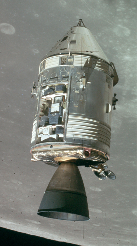 Figure 4. The Scientific Instrumentation Module (SIM) bay of the Apollo 15 Command/Service Module (CSM), Endeavour, is visible on the left side of the Service Module as shown in this photograph taken from the Apollo 15 Lunar Module (LM) Falcon. NASA Image AS15-152-23393. (NASA/JSC/ASU)
The mapping camera consisted of three systems: 1) The metric camera, which collected images of the lunar surface imprinted with reseau marks to compensate for film shrinking during processing 2) the stellar camera, which collected simultaneous exposures of the off-axis starfield in order to record the orientation of the spacecraft when each lunar image was obtained, and 3) the laser altimeter, which was used to determine and record the spacecraft's altitude over the lunar surface.
Because the Service Module would be ejected prior to the Command Module's reentry into the Earth's atmosphere, the exposed film from the camera systems in the SIM Bay had to be retrieved during the return journey to Earth through an extravehicular activity (EVA). The Command Module Pilots of the last three Apollo missions--Al Worden (Apollo 15), Ken Mattingly (Apollo 16) and Ron Evans (Apollo 17)--performed EVAs in cislunar space to retrieve the exposed film canisters from the SIM Bay (Figure 5).
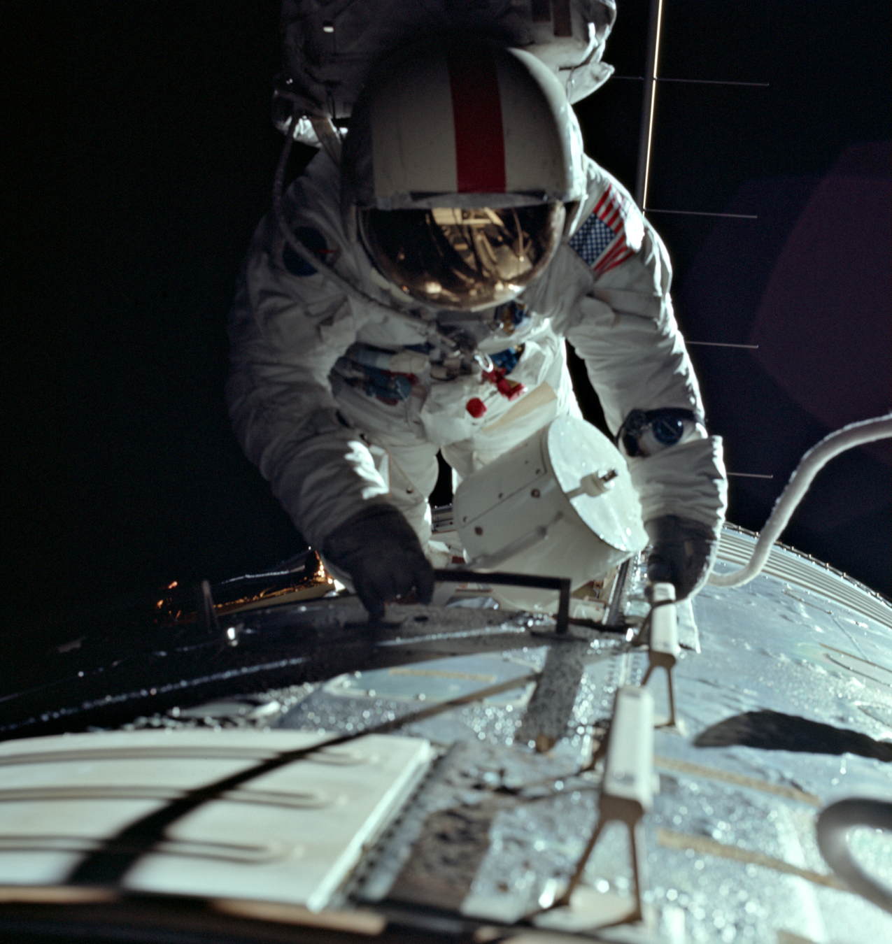 Figure 5. Apollo 17 astronaut Ron Evans retrieves a film canister from the Lunar Mapping Camera on board the Command/Service Module (CSM) America. The film canisters had to be retrieved from the exterior of the spacecraft before returning to Earth. NASA Image AS17-152-23393. (NASA/JSC/ASU)
During the course of Apollos 15, 16, and 17, over 7000 individual frames were produced by the Apollo Lunar Mapping Cameras, resulting in coverage of approximately 20% of the Moon's surface. During the Apollo era, the images from Apollo 15 and 16 proved to be fundamentally important for the training of subsequent lunar crews and the selection of future landing sites. After the premature end of the Apollo project in 1972, the data from the Apollo Lunar Mapping Cameras provided a wealth of information to scientists studying and mapping the lunar surface. The Apollo Lunar Mapping Camera images continue to be useful for geologists for studying lunar surface features and preparing for the next age of lunar exploration and development.
--Samuel Lawrence, Julie Stopar, and Mark Robinson, ASU
For more information, please refer to:
Apollo Over the Moon: The View from Orbit. Harold Masursky, G. W. Colton, Farouk El-Baz - NASA SP-362, 1978
Apollo Flight Journal: SIM Bay Camera Details by Robin Wheeler.

|
|
Space Exploration Resources |
|
 LPI LPI
|
