| Project Home | About the Scans | Browse Gallery | Image Map | Support Data | Resources | Ephemeris |
Featured Image - 05/19/2009
Leveed Rille in Mare Cognitum
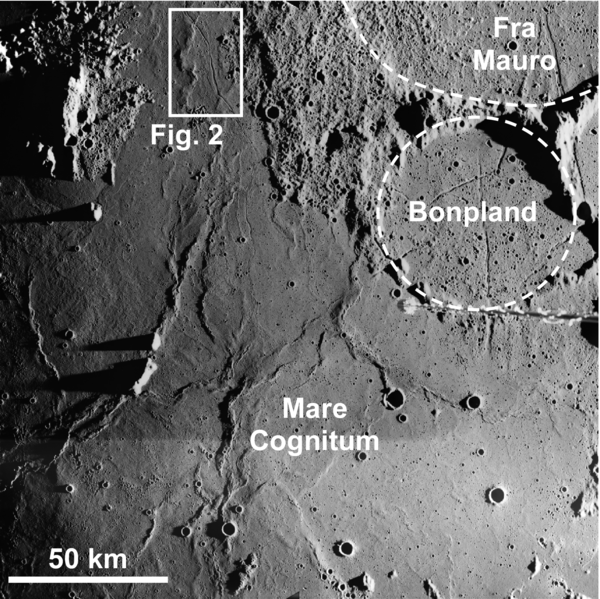
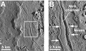
Large impact basins on the lunar nearside are filled in by lava flows. Despite fact that about 16% of the Moon’s surface is covered by lunar maria [Wilhelms, 1987], evidence of flow margins and flow fronts for these lava flows is scarce [Schaber et al., 1976]. South of the Apollo 14 landing site in the Fra Mauro highlands is a very unique lunar rille in Mare Cognitum adjacent to Craters Bonpland and Fra Mauro (Fig. 1). This lunar rille is different because it has levees adjacent to the channel (Fig. 2), whereas the majority of lunar sinuous rilles appear carved directly into the lunar surface. Levees are constructed as lava cools along the sides of the lava flow, creating a channel down the middle of the flow for the lava to continue down. The lava can overflow from the channel, splashing or flowing onto the levees, making them thicker [Sparks et al., 1977; Harris et al., 2008; Glaze et al., in press]. By measuring the dimensions of these levees, we can learn more about the eruptions that formed them and help distinguish why they are different from typical lunar rilles.
Figure 1. Young lunar lava flows in Mare
Cognitum embay ejecta from Craters Bonpland and Fra Mauro. Crater
rims are marked by the dashed white lines. Field of view of the
lava channel shown in Figure 2 is outlined by white box. (Apollo
Image AS16-M-1983 [NASA/JSC/Arizona State
University])
The lunar maria may look homogenous with the naked eye from Earth, but satellite data and samples from the Apollo missions indicate that they are very different with respect to age, geochemistry, and even natural surface color. The Lunar Reconnaissance Orbiter will obtain high- resolution remote sensing data sets that will be used to characterize the geochemical, spatial, and temporal differences between the lunar maria. This information will be used to help select potential landing sites for future human and robotic missions to the Moon. Knowing where different types of lava flows are on the Moon allows lunar scientists to plan a sampling strategy for future missions. These samples will provide insight into the ages and geochemical properties of the lavas and also tell us about their subsurface source regions.
Figure 2. (A) Close up of the lava channel. (B) The thick levees along the lava channel are marked by white arrows. (Apollo Image AS16-M-1983 [NASA/JSC/Arizona State
University]).
References:
Glaze, L.S., Baloga, S.M., Garry, W.B., Fagents, S.A., and Parcheta,
C., A hybrid model for leveed lava flows: Implications for eruption
styles on Mars. Journal of Geophysical Research, in press.
Harris, A.J.L., Favalli, M., Mazzarini, F., and Hamilton, C.W., 2009,
Construction dynamics of a lava channel. Bulletin of Voclanology,
v. 71, p. 459-474.
Schaber, G.G., Boyce, J.M., and Moore, H.J., 1976, The scarcity of
mappable flow lobes on the lunar maria: Unique morphology of the
Imbrium flows. Proc Lunar Sci Conf 7th:2783-2800
Sparks, R.S.J., Pinkerton, H., and Hulme, G., 1976, Classification and
formation of lava levees on Mount Etna, Sicily. Geology, v. 4,
p. 269-271.
Wilhelms, D.E., 1987, The Geologic History of the Moon. USGS
Professional Paper 1348, 302p.
Tweet
![]()

|
|
Space Exploration Resources |
|
 LPI LPI
|

