| Project Home | About the Scans | Browse Gallery | Image Map | Support Data | Resources | Ephemeris |
Featured Image - 04/21/2009
The Borderlands of Aristarchus: The Agricola Mountains and Agricola Straits
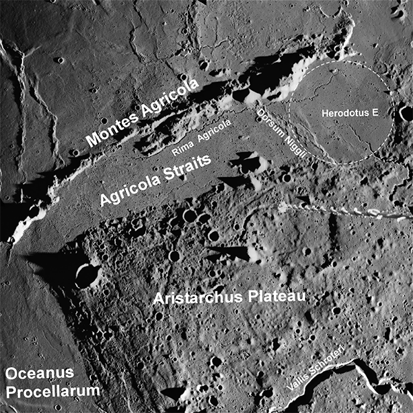
The Agricola Mountains are a linear ridge of peaks separated from the western margin of Aristarchus Plateau by the smooth mare basalts in the Agricola Straits, which is ~20-25 km wide. The mountain range is ~150 km long and rises up to ~1100 m above the surrounding terrain. Tracing the eastern edge of the ridge line is Rima Agricola, a lunar sinuous rille, which has tight gooseneck meanders that flow to the north toward Herodotus E, a crater buried by lava flows. Dorsum Niggli, a wrinkle ridge that is a tectonic scarp formed by thrust faulting, cross-cuts the straits near Herodotus E.
Figure 1. Annotated version of Apollo 15
metric image AS15-M-2202. The Agricola Stratis separate the western
margin of the Aristarchus Plateau from the Agricola Mountains. The
low Sun angle captures the dramatic topography and variety of geologic
features in this region including rilles, wrinkle ridges, and buried
craters (Apollo Image AS15-M-2202 [NASA/JSC/Arizona State
University]).
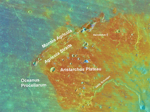
The Agricola Mountains serve as a unique divide between two geologic units defined by different colors observed in the Clementine color ratio image (Fig. 2) [Zisk et al, 1977; Lucey et al., 1986, McEwen et al., 1994, Chevrel et al., 2009]. On the eastern side of the ridge line, in the Agricola Straits, are mare deposits mantled by reddish pyroclastic volcanic material that also covers the majority of Aristarchus Plateau. To the west of the Montes Agricola are the younger, blue lava flows that embay the margin and the edges of the Plateau but do not infiltrate the Agricola Straits. This shows that mare surface within the straits have not been resurfaced by younger lava flows since the deposition of explosive volcanic material.
Figure 2. Clementine visible/near-infrared
"Color Ratio" overlain on a Lunar Orbiter mosaic. Notice the distinct
Red-Blue color boundary along the Montes Agricola. The lava flows
within the Agricola Stratis are covered by explosive volcanic
materials (red) and have not bee resurfaced by younger lava flows
(blue) that surround the western side of the Montes Agricola and
margins of the Aristarchus Plateau [USGS/NASA].
The incredible geologic diversity in the Aristarchus-Harbinger region makes this area one of the highest-priority areas for extensive future human lunar exploration. In fact, the Aristarchus plateau is considered to be one of the top sites for a permanent lunar outpost. Data from the upcoming Lunar Reconnaissance Orbiter mission will image the Aristarchus-Harbinger region and other high-priority potential human landing sites at high resolutions (50-cm/pixel) in order to prepare for the return of Americans to the lunar surface.
References:
Chevrel SD, Pinet PC, Daydou Y, Le Mouelic S, Langevin Y, Costard F,
Erard S (2009) The Aristarchus Plateau on the Moon: Mineralogical and
structural study from integrated Clementine UV-Vis-NIR spectral
data. Icarus 199:9-24
Lucey PG, Hawke BR, Pieters CM, Head JW, McCord TB (1986) A
compositional study of the Aristarchus region of the Moon using
near-infrared reflectance spectroscopy. J Geophys Res
91(B4):D344-D354
McEwen AS, Robinson MS, Eliason EM, Lucey PG, Duxbury TC, Spudis PD
(1994) Clementine observations of the Aristarchus Region of the
Moon. Science 266:1858-1862
Zisk SH, Hodges CA, Moore HJ, Shorthill RW, Thompson TW, Whitaker EA,
Wilhelms DE (1977) The Aristarchus-Harbinger region of the Moon:
Surface geology and history from recent remote sensing
observations. Moon 17:59-99

|
|
Space Exploration Resources |
|
 LPI LPI
|

