
| Project Home | About the Scans | Browse Gallery | Image Map | Support Data | Resources | Ephemeris |
Featured Image - 02/10/2009
Vallis Capella, Capella, and Isidorus
The lunar highlands are the exposed remnants of the Moon's primordial crust, and record billions of years of Solar System history. Since formation, both impact cratering and volcanic processes have controlled the landscape of the lunar highlands. Figure 1 [Apollo 16 metric Camera frame AS16-M-0424] shows a typical highlands region north of Mare Nectaris centered on Vallis Capella.
The fundamental geoscience principle of superposition (young features overlie older features) is just as applicable to the Moon and other planets as it is here on Earth. Planetary scientists can use images like Figure 1 to establish a relative time sequence for the emplacement of landforms.
After the Moon's formation in a giant impact, the anorthosite-rich crust was exposed to a prolonged period of heavy bombardment by asteroids and comets, which formed the large lunar basins. Studies of the samples returned by the Apollo astronauts show that the Nectaris basin (which contains Mare Nectaris, visible in the lower-left hand corner of Figure 1) was formed by an impact which occurred about 3.92 billion years ago. The heavily cratered surface in this scene is essentially the remant primordial lunar crust in the midst of the Necatris (to the south), Tranquillitatis (to the north), and Fecundidtatis (to the east) basins.
Smaller impacts subsequent to the major-basin forming events formed Capella and Isidorus craters. Capella crater (49 km in diameter) intrudes slightly into the eastern rim of Isidorus crater showing Capella to be the younger of the two. The promontory in the southeast of the Capella crater is probably a result of the rifting of Vallis Capella, which passes directly through crater from the north rim through the southeast rim, and extends out on both sides for a total distance of about 110 km. Plausible explanations for the origin of Vallis Capella include formation as a chain of impact craters, tectonic extension following the formation of the giant basins that surround this region, or as the mare fill increased its mass bowed down the crust. Later, mare basalts filled the Nectaris basin and infiltrated a portion of Vallis Capella in the southeast. Even later still, smaller impacts formed many 10-15 km diameter craters. One of the most pristine is Isidorus A crater, located within the older Isidorus crater. The most recent craters (within the last several hundred million years) are no larger than a few kilometers in diameter and have the brightest ejecta blankets, like the crater labeled with a "A" in Figure 1.
The upcoming NASA Lunar Reconnaissance Orbiter and especially its imaging system, the Lunar Reconnaissance Orbiter Camera, will provide key insights into small-scale structural details of surface features like the Vallis Capella with its high-resolution (0.5m/pixel) imagery as we prepare for the next generation of human lunar exploration and development.
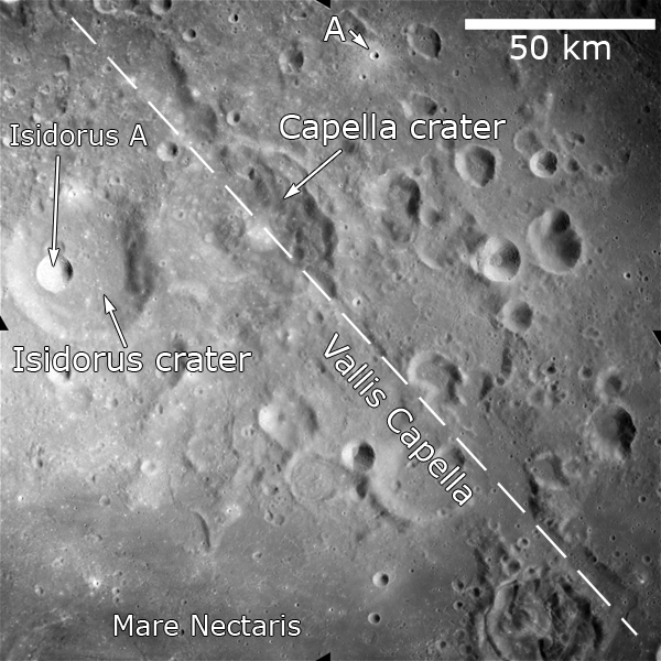
Figure 1. Apollo 16 Metric Camera frame AS16-M-0424 showing impact craters Isidorus (37 km diameter) and Capella (49 km diameter) and the Vallis Capella feature. The mare basalts in Nectaris basin are to the south, and the locations of the more recent Isidorus A crater and the small unnamed crater labeled with an "A" are highlighted on the image. The dashed white line marks the trending axis of the Vallis Capella feature. Image was taken on Apollo 16 revolution 18 with a Sun elevation of 37 degrees on April 20, 1972.
(Apollo Image AS16-M-0424 [NASA/JSC/Arizona State University])
References:
Bussey, B.; Spudis, P. (2004). The Clementine Atlas of the Moon. New York: Cambridge University Press. ISBN 0-521-81528-2.


|
|
Space Exploration Resources |
|
|