
| Project Home | About the Scans | Browse Gallery | Image Map | Support Data | Resources | Ephemeris |
Featured Image - 12/30/2008
Exploring the Lunar Highlands
On April 21, 1972, Apollo 16 astronauts John Young and Charlie Duke landed the Lunar Module (LM) Orion in the Descartes Highlands (see Figure 1), as Ken Mattingly orbited the moon in the Command and Service Module (CSM) Casper. Apollo 16 was the second of the Apollo J-Class missions, and featured an upgraded lunar module, improved spacesuits, a highly-instrumented CSM, and the Lunar Roving Vehicle(LRV). Apollo 16's primary focus was to sample the Descartes and Cayley formations in order to better understand the geology of the lunar highlands. Some leading theories prior to Apollo 16 suggested that the Descartes and Cayley formations were both volcanic in origin, so Apollo 16 was sent to this site in order to learn more about lunar highlands volcanic processes.
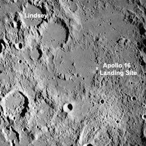
Figure 1. Apollo Metric image (frame ID AS16-M-0162) with Apollo 16 landing site marked [NASA/JSC/Arizona State University].
As a J-Class mission, Young and Duke used the LRV to perform three extra-vehicular activity (EVA) geologic traverses to collect samples and perform fieldwork. The collected samples included the single largest sample (weighing in at 11.7 kg [25 lbs]) ever returned to Earth during the Apollo project. During the three EVA's, Young and Duke traveled over 26.7 km visiting several craters (Flag, Spook, Wreck, and North Ray, see Figure 2) to sample possible bedrock material.
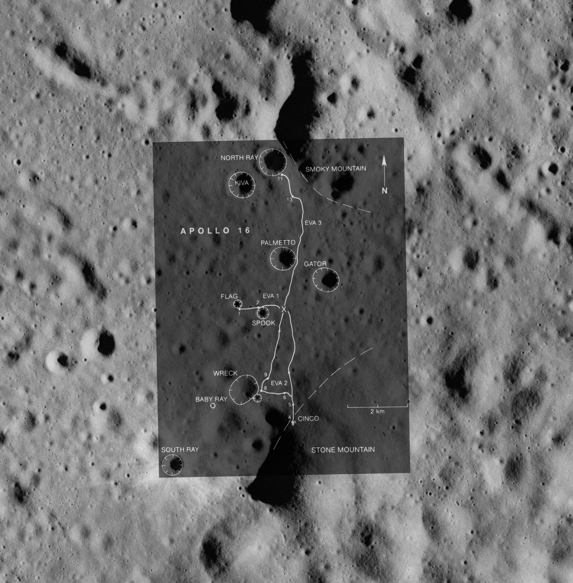
Figure 2. Zoomed-in portion of Apollo Metric image (frame ID AS16-M-0162) with overlay showing Apollo 16 EVA traverse paths [NASA/JSC/Arizona State University].
The fieldwork and samples collected by the Apollo 16 astronauts showed that the Descartes and Cayley formation materials at the Apollo 16 landing site were not volcanic in origin, but were rather impact breccias from both large, basin-forming impacts and related local secondary craters. The fieldwork and samples collected at the Apollo 16 site revolutionized our understanding of lunar geology. In fact, Apollo 16 was the only Apollo landing site outside of the Procellarum KREEP Terrane (PKT) as defined by Brad Jolliff and coworkers in 2000 using data returned by the Lunar Prospector spacecraft. The fact that the Apollo 16 site is geochemically somewhat distinct from the other Apollo landing sites makes the samples collected by Young and Duke incredibly important for modern-day researchers working to understand the geochemistry and petrology of lunar materials.
In April of 2009, NASA will launch the uncrewed Lunar Reconnaissance Orbiter (LRO) to the moon. LRO's primary goal will be to characterize key lunar surface attributes, including the topography of the lunar surface, lunar surface temperatures, mineralogy, and the lunar radiation environment. The information gathered during the LRO mission will be used to plan for the return of US astronauts to the lunar surface by helping to identity future landing and outpost sites. A key priority of the next age of human lunar exploration will be to continue the exploration of the lunar highlands begun by the Apollo 16 astronauts.
References:
- Apollo 16 Mission Report, NASA, MSC-07230, 1972, http://history.nasa.gov/alsj/a16/a16mr.html
- On the Moon with Apollo 16, NASA, EP-95, 1972, http://history.nasa.gov/EP-95/ep95.htm
- Jolliff, B. L., Gillis, J. J., Haskin, L. A., Korotev, R. L., Wieczorek, M. A. (2000) Major lunar crustal terranes: Surface expressions and crust-mantle origins. Journal of Geophysical Research, 105, E2, p. 4197-4216


|
|
Space Exploration Resources |
|
|