
| Project Home | About the Scans | Browse Gallery | Image Map | Support Data | Resources | Ephemeris |
Featured Image - 08/05/2008
If you were an Astronaut, would you land here?
Project Constellation will return human explorers to key scientific and economic targets on the Moon. For over four decades, the lunar science community has absorbed the information from the Apollo missions. Although many important questions were answered, many important new questions are waiting to be tackled.
There were six successful lunar landings. During the Apollo era, NASA and the lunar science community identified scientifically compelling landing sites from telescopic observations and orbital photography (from the US Lunar Orbiter spacecraft, as well as the Apollo missions themselves). One of the key drivers of site selection for the early Apollo missions, especially Apollo 11, was landing site safety. Apollo mission planners wanted a smooth surface with shallow topographic slopes for the first lunar landing. As the Apollo experience base grew, so did confidence, and the Apollo astronauts were able to successfully land at progressively more challenging sites with their continuously improving lunar hardware.
How can we determine the smoothness and slope of a surface on the Moon?
One of the most common methods is simply looking at the same surface under different solar illumination conditions. Shadows bring out topographic details that might not be visible near noon. Repeat imaging of a region on the lunar surface under different illumination conditions (both in terms of sun angle and direction) enables scientists to create detailed topographic maps - known as digital elevation models, or DEMs. DEMs allow quantitative scientific studies of a region's landforms, or geomorphology. Accurate measurements of local slopes are also critical for landing site evaluations, since shallow slopes are better landing targets.
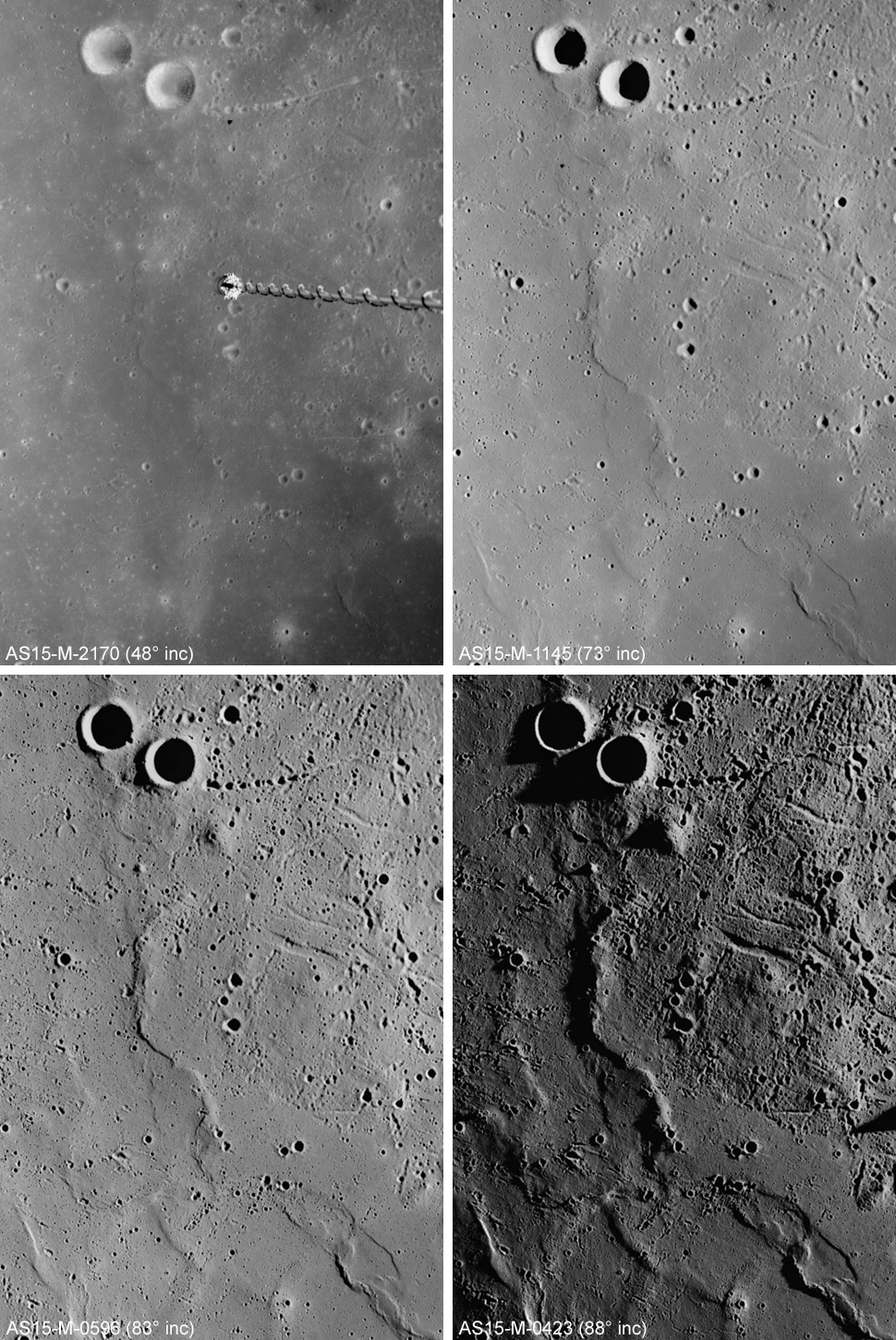
Figure 1. Four Apollo Metric frames of the same area in Mare Imbrium each taken under different solar illumination conditions (AS15-M-2170, AS15-M-1145, AS15-M-0596, and AS15-M-0423) [NASA/JSC/Arizona State University]
In Figure 1 we see the same region on the lunar surface under progressively different illumination conditions (this region was previously discussed in March 25 Apollo Featured Image). This week, you can see a series of four images that illustrate this important concept much more fully.
Each picture was taken on a different orbit as the relative positions of the Sun, the Moon, and the Apollo 15 Command Module Endeavour, as the relative positions of the Sun, the Moon, and the Endeavour progressed (upper left: solar incidence angle 48 degrees upper right: 73 degrees, lower left: 83 degrees, and lower right 88 degrees. In the upper left, Mare Imbrium appears flat and inviting; the image of the same area in the lower right looks rather forbidding.
The reality is that there are many safe landing places in Figure 1. This is why it is so important to re-image potential landing sites at various illumination angles to accurately portray the roughness and slope of a particular landing site. Data from both the upcoming Lunar Reconnaissance Orbiter Camera and the Lunar Orbital Laser Altimeter, which are both instruments aboard the Lunar Reconnaissance Orbiter, will be used by NASA to fully assess the roughness and topography of potential landing sites on the the lunar surface as we prepare for the seventh human lunar landing and beyond.
Tweet

|
|
Space Exploration Resources |
|
|