
| Project Home | About the Scans | Browse Gallery | Image Map | Support Data | Resources | Ephemeris |
Featured Image - 03/11/2008
Krieger Crater and Rimae, Aristarchus-Prinz Region
Apollo 15 Metric image AS15-M-2082, taken August 4th, 1971
Of the many volcanic structures found around the Aristarchus plateau, probably the most fascinating are sinuous channels, known as rilles. Scientists believe these channels were carved by massive outpourings of very hot lava. As this river of lava flowed across the plains, it not only melted its way into the surroundings but also formed levees in a fashion similar to overflowing rivers on the Earth. these huge channels that we now see are silent reminders of the Moon's very active volcanic past. The long, sinuous features in the southern and western halves of this scene are such features. There are at least 13 channels, and a few of these channels converge into one downstream from their origin in the southwest portion of the image. Rimae are probably the most recognizable small volcanic features on the Moon, as they resemble river valleys on the Earth. Because the lunar samples are absolutely free of water, the rimae probably resulted from flowing lava channels or collapsed lava tubes that formed during mare volcanism. The lunar flows may have melted their way down into older rocks, much like rivers cut into their flood plains on Earth. Typically, lunar rimae flow away from small pit structures (like some seen in this image).
Krieger crater is just left of center in this image and is located at 29.0°N, 45.6°W on the eastern part of Oceanus Procellarum. The superposed crater on the south rim of Krieger is called Van Biesbroeck. The two smaller craters just east and southeast of Krieger are Rocco and Ruth craters, respectively. To the south-southeast is the crater Prinz (rim just visible at bottom portion of image) and to the southwest is the crater Aristarchus. Aristarchus crater is beyond this image's extent but the rougher surface texture in the lower left portion of the image is the pyroclastic formation on the fringes of the Aristarchus Plateau. Northwest of Krieger crater lies Wollaston crater. The positive relief features to the east-southeast are the Montes Harbinger mountains. The rille emanating from the west side of Krieger crater appears to be incised into the rim of the crater thus indicating that it is younger than the crater. The crater likely filled with molten magma and when it overflowed the crater at the western rim, the lava rapidly cut through the rim and drained from the crater forming the sinuous channel that is visible today.
The long ridges trending north-northeast to south-southwest are known as wrinkle ridges. These features formed after the magmatic emplacement of the Oceanus Procellarum mare flood basalts while it cooled and contracted and are thus likely older that any other feature in the scene.
Note the linear features trending roughly east-west in the southern portion of the image. These are indicating the underlying structure of the uppermost lunar crust. The volcanic activity expressed on the surface was influenced by these structural controls.
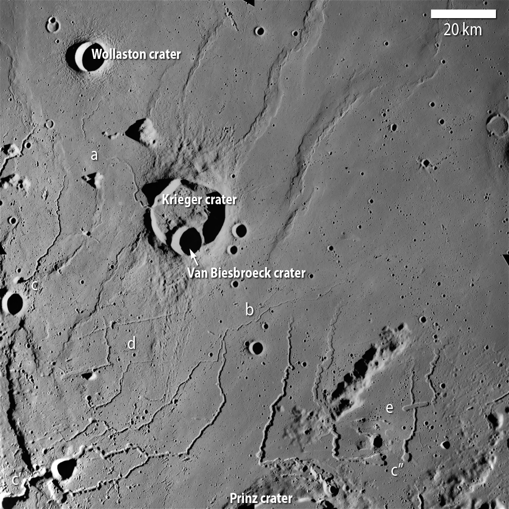
Apollo Metric image (frame ID AS15-M-2082) Upper right half of the image is the mare plains of Oceanus Procellarum. The rimae in the left portion of the image are of the Aristarchus rille complex and the rimae in the bottom right portion of the image are of the Prinz rille complex. The rille eminating from Kreiger crater is named Krieger rille. As these flows progressed, they spread laterally onto the plains to eventually fade into the plains material. Kreiger rille seems to superpose its channeled material onto an older rille structure at (a). At location (b) the rille seems to have deviated from an older path. Note the commonality of the rimae sources being circular pit structures at (c, c', and c'') where initially surfaced. Locations (d) and (e) are where the east-west linear features are well exposed. These are likely surface expressions of fracture planes within the subsurface that have either allowed for erosional pits to form on the surface looking like a channel (d) or as a vent for a magma source to reach the surface (e). It is also worth noting that some rille channels where in part controlled by these subsurface structures guiding their flow direction.
(Apollo Image AS15-M-2082 [NASA/JSC/Arizona State University])
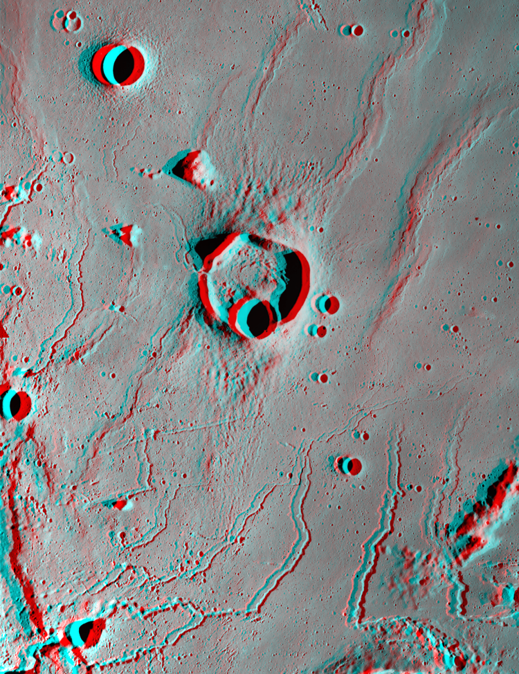
An anaglyph image of the above region using images AS15-M-2082 and AS15-M-2083 Using stereo imaging allows for the ability to more clearly see the historic relationships between the surface materials and features. The wrinkle ridge topography is much more clearly expressed and indicates that a major ridge was continuous before the impact of Kreiger crater. There also seems to be ejecta from this impact on top of the rille about four crater radii south of Kreiger.
(Apollo Image AS15-M-2082 [NASA/JSC/Arizona State University])


|
|
Space Exploration Resources |
|
|